
Empress is a small village in southeastern Alberta, Canada, situated on the southern bank of the Red Deer River adjacent to the Alberta–Saskatchewan border, approximately 9 km northwest of the confluence of the Red Deer River and the South Saskatchewan River. Incorporated in 1914 as a key railway divisional point on the Canadian Pacific Railway's "Royal Line," it served as a regional hub for agriculture, trade, and services in the early 20th century, with a population that once exceeded 800 residents. As of the 2021 Canadian Census, the village has a population of 148, occupying a land area of 1.58 square kilometres with a density of 93.5 people per square kilometre. The village experiences a semi-arid climate with cold winters and warm summers.[1][2]
The area's history extends far beyond European settlement, encompassing thousands of years of Indigenous presence by First Nations such as the Blackfoot, Cree, Stoney, Gros Ventre, and Arapaho, who utilized the river valleys for hunting, trade, and ceremonial sites, including buffalo jumps, medicine wheels, and teepee rings dating back 5,000 years.[1] The region is also renowned for its rich paleontological record, with fossils of dinosaurs, woolly mammoths, sharks, camels, and ancient turtles preserved in the local gravel deposits and riverbeds. European exploration began in the mid-18th century with figures like Anthony Henday, followed by fur trading posts at the river confluence, operating from 1800 to 1805 and briefly in 1820, which facilitated commerce but also introduced conflict and disease among Indigenous populations.[1]
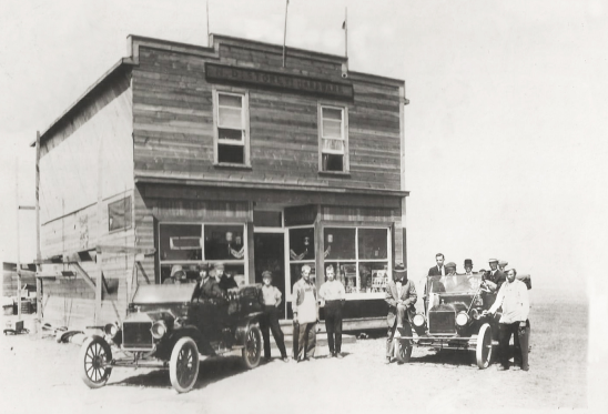
Settlement accelerated in the late 19th century with ranching in the 1880s and homesteading after Canadian Confederation in 1867, bolstered by Canadian Pacific Railway surveys in the 1870s. The village's founding in 1913—initially at a different site before relocation due to land speculation—coincided with railway construction, leading to rapid growth by 1915, including businesses, banks, hotels, churches, a school, and five grain elevators. The local newspaper, The Empress Express, operated from 1913 to 1936, documenting this boom period when the town was envisioned as "The Hub of the West" with multiple rail lines converging.[1]
Empress played a vital role as a service center for southeastern Alberta and southwestern Saskatchewan, particularly in healthcare and education. A cottage hospital opened in 1914, evolving into a 19-bed facility by 1942 and a 10-bed provincial hospital in 1982, which provided acute care until 2002 before transitioning to long-term care; notable physicians like Dr. Dan MacCharles and Dr. Archie McNeill served the community for decades, even generating local electricity in the early years. Education began with a private school in 1913, followed by a public district school in 1918 that expanded through the mid-20th century until its closure in 1996 due to rural consolidation. Five churches were established between 1913 and 1953, representing Anglican, Catholic, Lutheran, Pentecostal, and United denominations, though most have since closed amid population decline.[1]
The village's economy historically revolved around agriculture, ranching, and rail transport, with key industries today including farming, forestry, and transportation/warehousing, reflecting a labour force participation rate of 56% and employment rate of 47% as of 2021. Demographic characteristics show a median age of 54.0 years, with 31.0% of residents aged 65 or older, and a population primarily of European descent (e.g., German, Russian, Polish origins) speaking English as their mother tongue, alongside a small proportion with Low German roots. Christianity remains predominant, with 155 adherents reported in 2021.[2][1]
In the late 20th century, the discontinuation of the CPR line in the 1990s contributed to economic shifts, resulting in closures of the bank, stores, hospital acute services, and school, reducing the population to around 130 by the 2000s. Today, Empress preserves its heritage through the Empress Historical Society, historic sites like St. Mary the Virgin Anglican Church, and recreational opportunities amid prairies teeming with pronghorn, coyotes, and migratory birds, while continuing to support farming and ranching communities.[1]
History
Founding and Early Settlement
The area now known as Empress, Alberta, at the confluence of the Red Deer River and the South Saskatchewan River, has been inhabited by Indigenous peoples for thousands of years, with archaeological evidence of encampments dating back approximately 5,000 years.[1] Sites such as buffalo jumps, medicine wheels, teepee rings, drive lines, effigies, and altars indicate long-term habitation and cultural practices by groups including the Gros Ventre, Blackfoot and their allies, Stoney, Cree, and Arapaho.[1] These peoples relied on the region's resources, including bison herds, native grasses, berries, and the rivers, for sustenance, hunting, and seasonal migration, maintaining traditional ways of life largely unchanged until the mid-18th century.[1] The confluence served as a vital location for trade and gathering, though intertribal conflicts, particularly between the Cree and Blackfoot, were common, as noted during explorer John Palliser's 1859 expedition when securing local guides proved challenging due to ongoing hostilities.[1]
European contact began to transform the region in the late 18th century with the arrival of fur traders and explorers, such as Anthony Henday in the 1750s, who introduced horses and intensified competition among Indigenous groups.[1] By 1800, three fur trading posts operated at the river forks: Chesterfield House established by the Hudson's Bay Company under Peter Fidler, along with competing North West Company and XY Company forts, fostering trade in furs but also escalating violence, disease, and resource depletion until their closure around 1805.[1] A brief revival of Chesterfield House occurred in 1820, but the area saw limited European presence thereafter amid declining bison populations and persistent Cree-Blackfoot conflicts.[1] The Canadian Confederation of 1867 and subsequent surveys of western lands in the 1870s further disrupted Indigenous lifeways by promoting settler expansion and ranching.[1]
Non-Indigenous settlement patterns emerged in the late 19th century, initially through open-range ranching operations that arrived in the 1880s, capitalizing on the vast prairies near the rivers.[1] The completion of the Canadian Pacific Railway (CPR) in the 1880s, following initial surveys in the 1870s, significantly accelerated immigration and land use changes by providing access to remote areas and encouraging homesteading under the Dominion Lands Act of 1872, which offered 160-acre plots to settlers for a nominal fee in exchange for cultivation and residency requirements.[3][1] Homesteaders, motivated by promises of fertile land and economic opportunity, began breaking sod for farming in the early 1900s, transitioning the region from ranching dominance to mixed agriculture.[1] This influx was bolstered by the CPR's role in connecting settlers to markets, setting the stage for formalized communities.
Empress itself was named in 1913, honoring Queen Victoria's title as Empress of India, granted by the British Parliament in 1877, during a period of rapid railway expansion in southern Alberta.[4] The site's selection for a major CPR divisional station—envisioned as the "Hub of the West" due to its flat terrain, gravel deposits, and river access—drew initial pioneers seeking homesteads and rail-related prospects under the Dominion Lands Act.[1][3] Early settlers, including ranchers and farmers, were primarily drawn by the act's incentives, arriving to establish claims amid the broader wave of prairie immigration facilitated by the railway.[1]
Development and Incorporation
Following the naming of the settlement in 1913, the Village of Empress was officially incorporated on February 5, 1914, after relocation to its current site to capitalize on the Canadian Pacific Railway (CPR) divisional point along the Royal Line.[1][5][6] This formal establishment attracted homesteaders and businesses, with the CPR auctioning town lots starting at $10, fostering immediate development amid expectations of it becoming a major rail hub west of Winnipeg.[5] By late 1914, the community had grown to over 200 residents, supported by an active board of trade and the completion of the rail line crossing the South Saskatchewan River.[7]
The village experienced rapid population expansion in the ensuing years, reaching approximately 750 by 1916 and climbing to around 850 by 1927, with local accounts estimating a peak exceeding 1,200 in the 1920s.[8][9][5] This boom was propelled by agricultural opportunities in the surrounding prairie and the rail services that connected farmers to markets, enabling the shipment of grain and supplies. Key infrastructural milestones included a private school established in 1913, followed by the construction of the first public school, a two-storey Kitchener School, in 1918 to accommodate over 100 students.[1] Grain elevators, essential for the farming economy, proliferated with five operational facilities by the early 1920s, facilitating efficient storage and transport via the CPR tracks.[1]
The outbreak of World War I in 1914 disrupted this initial momentum just months after incorporation, slowing immigration and development as resources shifted to the war effort, though the rail infrastructure continued to support local homesteading.[5] Community resilience was evident in efforts like establishing a public school district and basic healthcare amid wartime challenges, including the 1918 flu epidemic managed by arriving physician Dr. Dan MacCharles.[1] The Great Depression of the late 1920s exacerbated economic strains, with falling grain prices and reduced trade impacting the rail-dependent village, yet adaptations such as expanding the cottage hospital in 1936 using repurposed buildings helped sustain essential services during the hardship.[1]
Geography
Location and Topography
Empress is situated in southeastern Alberta, Canada, within Census Division No. 4. The village lies at coordinates approximately 50°57′N 110°00′W and is incorporated as a municipality adjacent to the Alberta-Saskatchewan provincial border, with portions of its eastern residential areas extending into Saskatchewan.[10][11][12]
Administratively, Empress falls within the Municipal District of Acadia No. 34, a municipal district in southeastern Alberta.[13] It is located about 137 km north of Medicine Hat via Alberta Highway 41, from which the village sits approximately 5 km to the east, and roughly 67 km south of Oyen. This positioning places Empress at the confluence of the Red Deer River and South Saskatchewan River, anchoring its role in the regional landscape.[11][14]
The topography surrounding Empress features gently undulating glacial till plains typical of the Dry Mixedgrass Natural Subregion, with low local relief under 20 meters and slopes generally less than 5%. This area is part of the broader Southern Prairies, often referred to as Palliser's Triangle, a dry steppe region noted for its aridity and suitability for dryland farming. Elevations in the vicinity range from 550 to 650 meters above sea level, averaging around 610 meters.[15][16][17]
Rivers and Natural Features
The village of Empress is situated between the Red Deer River and the South Saskatchewan River, immediately west of their confluence, which occurs a short distance east of the community in Saskatchewan and marks the eastern boundary of Alberta's prairie landscape.[18] This junction creates a dynamic hydrological feature where the Red Deer River, flowing southeast from its headwaters in the Rocky Mountains, merges with the larger South Saskatchewan River system, contributing to the region's water flow and sediment transport.[19]
These rivers play a crucial role in shaping the local environment, particularly through periodic flooding that deposits nutrient-rich sediments onto floodplains, enhancing soil fertility in the surrounding Chernozemic soils characteristic of the Dry Mixedgrass subregion. Fluvial and glaciofluvial deposits from the rivers support productive riparian zones and adjacent grasslands, fostering agricultural viability while also influencing erosion patterns in the area.[20] The rivers' historical flood events have redistributed these sediments, promoting soil development in low-lying areas near Empress, though such events also pose risks to infrastructure and habitats.[21]
Surrounding Empress, the landscape features prominent badlands, coulees, and expansive prairie grasslands, sculpted by river erosion into rugged terrains of Cretaceous shales and sandstones. Badlands along the Red Deer and South Saskatchewan rivers exhibit dramatic cutbanks, slump blocks, and exposed slopes that contrast with the rolling grasslands dominated by shortgrasses like blue grama and speargrass, supporting diverse flora such as prickly pear cactus and silver sagebrush.[20] These features bolster biodiversity, providing habitats for wildlife including pronghorn antelope, coyotes, ferruginous hawks, and piping plovers in riparian corridors and sagebrush flats.[19][18]
Conservation initiatives in the region emphasize protecting riparian zones along these rivers, which serve as critical wildlife corridors and buffers against erosion. Environmentally significant areas near Empress, such as the South Saskatchewan River Canyon and Dune Point-Bindloss-Empress Terraces, are prioritized for their intact cottonwood ecosystems and native prairie remnants, with efforts focusing on limiting development and promoting sustainable grazing to maintain habitat integrity for species like the loggerhead shrike and mule deer.[20][19]
Demographics
Population Trends
According to the 2021 Census of Population conducted by Statistics Canada, the Village of Empress recorded a total population of 148 residents, marking a 9.6% increase from the 135 residents enumerated in the 2016 Census.[22] This recent uptick contrasts with the village's long-term trajectory of decline.
Historically, Empress experienced significant growth in its early years following incorporation in 1913, reaching a peak population of 850 by 1927 amid regional agricultural expansion and railway development.[23] However, subsequent decades saw steady erosion, with the population falling to 489 in 1960 and further to 360 by 1970, reflecting the challenges of mechanized farming, economic shifts, and out-migration in prairie communities.[24][25]
Housing data from the 2021 Census underscores the village's small scale, with 112 total private dwellings, of which 69 were occupied by usual residents, indicating a vacancy rate of about 38% amid the sparse population.[22] As of 2024, the estimated population has risen to 175, continuing the recent growth trend.[26] While no official projections exist for Empress specifically, regional analyses suggest continued vulnerability to depopulation pressures unless offset by local economic revitalization or infrastructure improvements to retain families.[26]
Ethnic and Social Composition
The residents of Empress are predominantly of European descent, with ancestry rooted in German, Russian, Polish, English, and Scottish origins from early settlers. According to the 2021 Census of Population, the village has a low visible minority population of 0%, reflecting its homogeneous cultural makeup.[22]
The median age in Empress is 54.0 years, contributing to an aging demographic profile. The gender distribution is approximately equal, with 50% males and 50% females, as of the 2021 Census.[22]
English is the primary language spoken in the community, with nearly all households monolingual in English; bilingual households exist but represent a small minority. Social indicators highlight a stable family-oriented structure, including a high marriage rate among adults.[22]
Economy
Agriculture and Farming
Agriculture in Empress, Alberta, centers on dryland grain farming and livestock production, reflecting the semi-arid conditions of the Palliser Triangle region. The primary crops include wheat as the dominant field crop, alongside canola, barley, oats, and flax, which together account for the majority of cultivated land in the surrounding area.[27] Livestock operations feature cattle ranching, with a growing emphasis on hog production, contributing to a mixed but increasingly specialized agricultural economy.[27][28]
The South Saskatchewan River provides limited irrigation support in this dryland farming zone, helping to mitigate the challenges of low precipitation and sandy soils typical of southeastern Alberta.[1] While most operations rely on natural rainfall, proximity to the river enables supplemental watering for some crops and livestock, enhancing resilience in an otherwise arid environment.[29]
Local farming cooperatives emerged in the early 20th century, with grain elevators playing a pivotal role in storage and marketing. By 1915, five elevators operated in Empress to handle local grain output, and the Alberta Wheat Pool established a presence in the 1920s, organizing farmers for collective bargaining and efficient distribution.[1][30]
Farmers in the Empress area have faced persistent challenges from droughts and volatile grain markets, particularly in the dry belt where crop failures have historically led to economic strain.[29] Post-World War II, agricultural practices shifted from mixed farming—combining grains and diverse livestock—to greater specialization in grain production and cattle operations, driven by mechanization and market demands.[31]
Energy and Other Sectors
The energy sector in Empress, Alberta, is dominated by oil and gas activities in the surrounding prairies, where shallow gas wells and pockets of oil support local exploration and production.[27] The area benefits from its proximity to major trade corridors like Highway 41, facilitating transportation and servicing for the broader oil sands industry.[27] Key infrastructure includes the Empress Gas Liquids Joint Venture, operated by AltaGas, which processes up to 1,100 MMscf/d of natural gas to extract ethane and natural gas liquids, connecting to extensive pipeline networks for distribution across western Canada.[32]
Renewable energy is emerging in the region, exemplified by the Empress Solar project south of the village near the Alberta-Saskatchewan border. This 38.5 MW ground-mounted solar photovoltaic facility, developed by ATCO, spans 270 acres with 89,000 panels and supplies clean energy equivalent to powering approximately 11,000 homes, with operations ramping up following its 2021 acquisition and 2023 power purchase agreements.[33][34]
The service economy in Empress supports the local community through small-scale retail, tourism assistance, and basic trades. Retail outlets like That's Empressive, a gallery and gift shop at 309 Centre Street, provide unique creative items, women's jewelry, handmade ceramics, limited groceries, home-baked goods, and fuel services, catering to both residents and visitors exploring the Canadian Badlands.[35][36] Tourism-related services are growing, including support for outdoor pursuits such as canoeing, hiking, hunting, and fishing expeditions in the rural setting.[27] Basic trades and business services round out the sector, leveraging the village's location for regional economic ties.[27]
Employment in Empress, as of the 2021 Census, shows a labour force of 95 people aged 15 and over, with a participation rate of 55.9%, employment rate of 44.1%, and unemployment rate of 15.8%.[2] Occupations in the labour force include trades, transport and equipment operators (31.6%), natural resources, agriculture and related production (21.1%), business, finance and administration (10.5%), health (10.5%), and sales and service (10.5%), with no reported occupations in management, sciences, education, or arts.[2] This structure underscores the interplay between energy, services, and local trades, though the small population often supplements opportunities through regional connections.[37]
Climate
Seasonal Weather Patterns
Empress, Alberta, features a semi-arid climate classified as BSk under the Köppen-Geiger system, characterized by cold, dry winters and warm, relatively short summers influenced by its location in the Palliser's Triangle region of the Canadian prairies.[38] This classification reflects the area's low precipitation and continental temperature extremes, with seasonal patterns driven by polar air masses in winter and warmer southerly flows in summer. Winters (December to February) are prolonged and frigid, while summers (June to August) bring approximately 45% of the region's limited moisture through convective thunderstorms.
Average temperatures illustrate these cycles clearly: the January mean low reaches -14°C, marking the coldest month, while July sees a mean high of 28°C during the warmest period.[39] Annual precipitation totals approximately 330 mm, with the majority occurring from May to September, particularly June, which averages 74 mm of rainfall from frequent but localized storms.[39] Winters contribute minimally, often as snow rather than rain, reinforcing the dry conditions typical of the steppe environment.
Wind plays a prominent role in local weather dynamics, with year-round averages of 15-25 km/h, peaking in spring.[39] Chinook winds, warm downslope flows from the Rocky Mountains, occasionally disrupt winter patterns in southern Alberta, including Empress, bringing rapid thaws and temperature spikes up to 20°C above normal during events that can last hours to days.[40] The proximity of the South Saskatchewan River, which borders the community, provides minor moderation to temperature extremes by fostering localized humidity and buffering against the harshest continental swings.
Historical Climate Data
Historical climate data for Empress, Alberta, is primarily derived from nearby weather stations, such as Medicine Hat RCS (approximately 115 km southeast), due to the limited duration of direct observations at the local site. The all-time record high temperature in the region reached 42.2°C on July 12, 1886, while the record low was -46.1°C on February 4, 1887.[41] More recent extremes include a high of 40.6°C observed in 1937 and a low of -39.3°C in December 1996, reflecting the area's capacity for significant thermal variability.[42][43][44]
Long-term trends indicate warming temperatures across the Canadian Prairies, with average annual temperatures in Alberta increasing by about 1.7°C since 1948, particularly in summer (2.1°C rise) and autumn (2.4°C rise). Precipitation patterns remain variable, with notable droughts affecting the region in the 1930s—often termed the "Dust Bowl" era—and the 1980s, both periods marked by severe moisture deficits that impacted agriculture and water resources.[45][46]
Environment Canada records from 1991 to 2020 for the Medicine Hat area, applicable to Empress, show approximately 2,544 hours of sunshine annually, underscoring the region's arid, sunny climate. These datasets also highlight ongoing variability in precipitation, averaging around 330 mm per year but with fluctuations tied to larger climatic oscillations.[47]
Climate change is projected to exacerbate certain extremes in southern Alberta, including the potential for more intense storms and associated heavy precipitation events, as evidenced by recent patterns of severe weather impacting the Prairies.[48]
Government and Services
Local Administration
The Village of Empress was incorporated as a village in 1914 and operates under Alberta's Municipal Government Act as a municipal corporation providing local governance to its residents.[1][5] It is governed by a council comprising a mayor and two councillors, all elected at large for staggered four-year terms, with the mayor and deputy mayor roles selected annually from among the council members.[49][50]
As of early 2025, the council consists of Mayor Dawna Martin, Deputy Mayor Kelly Burgess, and Councillors Clint Steinley and [second councillor if updated; but based on info, assuming Steinley acclaimed]. Recent by-elections, including one in 2024 declared by acclamation in September for the councillor position to Clint Steinley, have maintained this structure following changes due to resignations.[51][52]
The Chief Administrative Officer (CAO), Jerry Gautreau, appointed effective January 15, 2025, manages daily operations, including bylaw enforcement, financial oversight, and policy implementation on behalf of the council.[53][54]
Municipal policies prioritize essential rural services, such as infrastructure maintenance and resource management, with a particular emphasis on water supply and wastewater systems to support the community's needs in a semi-arid region.[6][54]
The village's 2024 actual expenses totaled $758,306, funded primarily through property taxes ($193,962 in net municipal taxes), government grants and transfers ($546,191), and other revenues like user fees and sales of goods.[54]
Infrastructure and Utilities
Empress relies on a combination of municipal and regional providers for its essential utilities. The Village of Empress manages water, sewer, and garbage services, billing residents bimonthly at rates including $80 base for water plus $2.05 per cubic metre, $50 for sewer, and $50 for garbage as of 2024. Electricity distribution is handled by ATCO Electric, which residents contact for outages via their Oyen office or toll-free line. Natural gas heating is supplied by the Dry Country Gas Co-Op Ltd., based in nearby Oyen.[55]
Transportation infrastructure in Empress centers on road and air access, with limited rail presence. Alberta Highway 899 serves as the primary route connecting the village to surrounding areas, including ongoing rehabilitation projects for repaving south of the community. The historic Canadian Pacific Railway station, built in 1914 and designated a Provincial Historic Resource in 2002, reflects the area's past rail significance, though the line has since been removed. The Empress Airport (CYEA), operated by the village and located 2 km south at an elevation of 674 metres, features a 900-by-23-metre asphalt runway accessible via Highway 899, offering basic facilities like a shelter but no fuel or toilets.
Healthcare and education services are provided regionally due to the village's small size, supplemented by local emergency response. Residents access medical care through the Oyen Medical Clinic, staffed by three physicians and nurses, and the nearby Big Country Hospital, which offers 24/7 emergency services, acute care beds, and specialties like physiotherapy about 30 km north. There is no local K-12 school in Empress; students are bused to Warren Peers School for grades K-9 in Acadia Valley (37 km north) or South Central High School for grades 10-12 in Oyen (68 km north), both part of the Prairie Rose School Division serving around 3,300 students province-wide. The Empress Volunteer Fire Department operates from a fire hall at 314 3rd Avenue West, providing basic life support and participating in regional emergency responses as a registered Alberta Medical First Response agency.
Broadband and telecommunications in Empress emphasize wireless solutions amid rural constraints. Fixed wireless internet is available through Mascon by Telus, following the 2022 acquisition of local provider Netago, while satellite options include Starlink and Xplore for broader coverage. Fiber optic infrastructure reaches the community via Alberta's SuperNet program, established in the early 2000s to connect rural areas, enabling basic high-speed access though primarily delivered wirelessly to homes. Landline and mobile services operate on Telus and Rogers networks.[56]
Culture and Attractions
Community Events and Heritage
Preservation efforts center on the Empress and District Historical Society, which restored the 1913 Canadian Pacific Railway station into a museum over more than a decade, culminating in its opening during the village's 2014 centennial celebrations. The site displays artifacts from the 1910s rail era, including planned exhibits of period benches, luggage, telegraph equipment, and a section of tracks, highlighting Empress's origins as a intended rail hub between Swift Current and Calgary before World War I disruptions. The society conducts summer fundraising events to maintain the facility, which is also available for small community gatherings, and welcomes donations of rail-era items like old trunks or train schedules.[57]
Local history books compiled by community groups provide detailed accounts of early settlers and pioneer life in Empress and surrounding districts. Notable examples include Echoes of Empress Through 75 Years: 1914–1989, published by the Empress Historical Society in 1990, which covers settlement from the village's founding through community milestones, and Golden Jubilee: Empress, 1914–1964, a 1964 commemoration of 50 years of progress featuring stories of homesteading families in areas like Ainslee, Glevennah, and Langholm. These volumes emphasize the challenges and cultural transitions of prairie pioneers, drawing on personal narratives to preserve the area's heritage.[58]
Artisan crafts form part of the community's cultural activities, with regular drop-in sessions for sewing, knitting, crocheting, and scrapbooking held on Mondays at the Empress Community Hall, encouraging skill-sharing and creative expression among residents. These gatherings, supported by available sewing machines and supplies, reflect ongoing traditions of handmade goods in the rural setting.[59]
Outdoor Recreation and Sites
Empress offers a variety of outdoor recreational opportunities centered on its riverine location and prairie landscape. The South Saskatchewan River and nearby Red Deer River provide excellent venues for boating, including kayaking and canoeing, with easy access points like the old ferry crossing near the village. Fishing is popular on these rivers, where anglers can target species such as walleye, goldeye, northern pike, and burbot through guided tours or independent outings. Birdwatching is another highlight, with the rivers attracting diverse waterfowl and prairie species like sharp-tailed grouse, offering spectacular views during migration seasons.[18][60][61]
Within the village, recreational facilities include a golf driving range established in 2009, available for a nominal fee per bucket of balls, catering to casual players seeking practice in a scenic setting. Adjacent to this, the Last Man Standing Paintball Field provides an action-oriented outdoor experience on dedicated courses, suitable for groups and emphasizing safety and fun in the open prairie terrain. These local amenities complement the natural surroundings, allowing visitors to engage in low-key sports year-round.[62][63][64]
Hiking trails are accessible nearby, notably the interpretive trail at Peter Fidler Park, which winds along the Red Deer River valley and highlights local history and ecology through marked paths suitable for all skill levels. For more extensive exploration, Writing-on-Stone Provincial Park, located approximately two hours south by car, features rugged hoodoos, petroglyphs, and extensive hiking routes amid badlands scenery, drawing adventurers from the Empress area.[65][66]
In winter, the flat prairies around Empress support cross-country skiing, with informal trails offering serene traverses across snow-covered fields and riverbanks.[63]
References
https://villageofempress.com/visitors/history/
https://www12.statcan.gc.ca/census-recensement/2021/dp-pd/prof/details/page.cfm?Lang=E&SearchText=Empress&DGUIDlist=2021A00054804006&GENDERlist=1,2,3&STATISTIClist=1&HEADERlist=0
https://thecanadianencyclopedia.ca/en/article/dominion-lands-policy
https://thecanadianencyclopedia.ca/en/article/victoria
https://www.empressive.ca/village-history.html
https://open.alberta.ca/dataset/5bfed4fe-e139-4597-8d14-4bf4db045ac9/resource/e64e1402-35af-4fc3-922d-ddeecf4c0222/download/6534653-2011-village-of-empress-municipal-inspection-report-july-2011.pdf
https://hermis.alberta.ca/ARHP/Details.aspx?DeptID=2&ObjectID=HS%2031946
https://open.alberta.ca/dataset/daab9fce-c2f6-49d1-a433-375b2b7aee24/resource/4c44322e-b2c8-4564-b750-25ae60fc1003/download/population1916.pdf
https://open.alberta.ca/dataset/daab9fce-c2f6-49d1-a433-375b2b7aee24/resource/d46ccc08-5762-43c4-bc28-c92e537c63cf/download/population1927.pdf
https://www12.statcan.gc.ca/census-recensement/2016/dp-pd/prof/details/page.cfm?Lang=E&Geo1=CSD&Code1=4804006&Geo2=CD&Code2=4804&SearchText=empress&SearchType=Begins&SearchPR=01&B1=All&TABID=1&type=0
https://villageofempress.com/visitors/where-is-empress/
https://www.mapquest.com/ca/alberta/empress-282172427
https://mdacadia.ab.ca/
https://www.distance-cities.com/ca/distance-empress-ab-to-medicine-hat-ab
https://open.alberta.ca/dataset/dd01aa27-2c64-46ca-bc93-ca7ab5a145a4/resource/98f6a93e-c629-46fc-a025-114d79a0250d/download/2006-nrsrcomplete-may.pdf
https://www.canada.ca/en/canadian-heritage/services/provincial-territorial-symbols-canada/alberta.html
https://en-ng.topographic-map.com/map-fsr73l/Empress/
https://villageofempress.com/rivers/
https://www.albertawilderness.ca/issues/wildwater/red-deer-river/
https://open.alberta.ca/dataset/9edda965-8686-4630-b0f5-cd87affa0c08/resource/6fd4c443-d39c-43d2-be5e-22611cd47bff/download/1997-grassland-natural-region-of-alberta-report.pdf
https://rdrwa.ca/wp-content/uploads/2020/10/rdr_sowr_0_0_frontmatter4.pdf
https://www12.statcan.gc.ca/census-recensement/2021/dp-pd/prof/details/page.cfm?Lang=E&SearchText=Empress&DGUIDlist=2021A00054804006
http://www.municipalaffairs.gov.ab.ca/documents/ms/population1927.pdf
http://municipalaffairs.gov.ab.ca/documents/ms/population1960.pdf
http://municipalaffairs.gov.ab.ca/documents/ms/1970population.pdf
https://regionaldashboard.alberta.ca/region/empress/population/
https://albertainfo.palliseralberta.com/albertainfo/pdf/TheVillageofEmpress_Investment_Profile.pdf
https://villageofempress.com/wp-content/uploads/2017/01/Meat-Snacks.pdf
https://www.producer.com/news/work-continues-on-dream-to-irrigate-eastern-alberta/
https://archive.org/details/EPE_1920120201
https://www.history.alberta.ca/energyheritage/energy/human-and-animal-power/animal-power-in-modern-times/animal-power-in-modern-alberta-agriculture.aspx
https://www.altagas.ca/infrastructure/operations/empress-gas-liquids-joint-venture
https://www.atco.com/en-ca/about-us/projects/empress-solar.html
https://www.power-technology.com/data-insights/power-plant-profile-empress-solar-pv-power-project-canada/
https://www.empressive.ca/
https://www.travelalberta.com/listings/thats-empressive-3383
https://regionaldashboard.alberta.ca/region/empress/
https://seawa.ca/your-watershed/profile-of-the-seawa-watershed
https://www.timeanddate.com/weather/@5948716/climate
https://thecanadianencyclopedia.ca/en/article/chinook
https://www.extremeweatherwatch.com/cities/medicine-hat
https://www.extremeweatherwatch.com/cities/medicine-hat/year-1937
https://www.extremeweatherwatch.com/cities/medicine-hat/year-1996
https://climate.weather.gc.ca/historical_data/search_historic_data_e.html
https://www.canada.ca/en/environment-climate-change/services/environmental-indicators/temperature-change.html
https://open.alberta.ca/dataset/cee3d571-9d0f-4b8c-a71f-2c2b1f4616f9/resource/4200f0af-4077-4740-a546-5f085d6a0ad1/download/aenv-canadian-prairie-drought-a-climatological-assessment-6673.pdf
https://www.currentresults.com/Weather/Canada/Alberta/sunshine-annual-average.php
https://www.canada.ca/en/environment-climate-change/services/ten-most-impactful-weather-stories/2024.html
https://villageofempress.com/council/2021-election/
https://villageofempress.com/council/2022-municipal-by-election/
https://villageofempress.com/2024-municipal-by-election/
https://villageofempress.com/announcements/2024/09/10/by-election-results/
https://villageofempress.com/announcements/2025/01/10/empress-hires-a-new-chief-administrative-officer/
https://villageofempress.com/wp-content/uploads/2025/07/Village-of-Empress-Dec24-Final-Financial-Statements-with-signatures.pdf
https://villageofempress.com/council/rates-fees/
https://ecareview.com/netago-internet-service-acquired-by-telus/
https://www.empressive.ca/things-to-do.html
https://www.abgenealogy.ca/uploads/files/Resources/AlbertaHistories.pdf
https://villageofempress.com/residents/events/
https://www.travelalberta.com/listings/jcs-river-fishing-12727
https://villageofempress.com/visitors/bird-watching/
https://villageofempress.com/residents/golf-driving-range/
https://villageofempress.com/visitors/what-to-do-in-the-area/
https://411.ca/business/profile/6384920
https://www.travelalberta.com/listings/peter-fidler-park-12769
No comments:
Post a Comment