
 The Hand Hills of southeastern Alberta rise abruptly from the surrounding plains, offering unparalleled 360-degree vistas that encapsulate the vastness and ecological diversity of the Canadian Prairie. This elevated landform, reaching up to 970 meters above sea level112, serves as a natural observatory where visitors can survey the interplay of grasslands, badlands, and human history. Below, we analyze the geological, ecological, and topographical factors that make the Hand Hills a unique viewpoint.

Geological Foundations of Elevated Perspectives
Tertiary Conglomerate Cap and Erosion Resistance
The Hand Hills owe their prominence to a Tertiary-era conglomerate cap219, a dense layer of gravel and sandstone that has resisted glacial and fluvial erosion over millions of years. This geological armor has preserved the hills’ elevation, which stands ~500 feet (150 meters) above the adjacent plains612. Unlike the softer sedimentary layers of the surrounding badlands, the conglomerate has slowed erosion, creating a mesa-like plateau that dominates the horizon619. The resistant cap also exposes ancient strata, including Cretaceous-period sandstones and shales, which are visible along the hills’ slopes13.
Glacial Legacy and Topographic Contrast
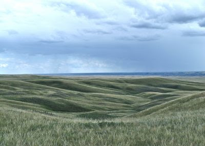
During the Pleistocene epoch, glaciers sculpted much of Alberta’s landscape, but the Hand Hills’ conglomerate shield allowed them to remain as a "glacial outlier"15. The resulting knob-and-kettle topography—a mix of rounded hills and water-filled depressions—enhances visual interest when viewed from the plateau1115. This contrast between the elevated, intact hills and the eroded plains below creates a dramatic backdrop for panoramic observation.
Ecological Openness and Unobstructed Sightlines
Northern Fescue Grassland Canopy
As part of the Northern Fescue Natural Subregion, the Hand Hills are blanketed by native grasses such as porcupine grass, June grass, and spear grass11215. These low-growing species maintain open sightlines across the plateau, avoiding the visual barriers posed by forests or shrubs. The grasslands’ golden hues in autumn and emergent green in spring add chromatic depth to the vistas1115.
Wildlife Corridors and Avian Perspectives
The hills’ elevation and ecological richness make them a critical habitat for species like ferruginous hawks and prairie long-tailed weasels111. Birdwatchers often spot raptors soaring above the plains, leveraging thermal updrafts generated by the hills’ elevation1112. The Handhills Lake Important Bird Area, located nearby, further enriches the skies with migratory shorebirds and waterfowl, visible from the plateau’s edge20.
Human and Historical Dimensions
Indigenous and Pioneer Sightlines
For millennia, Indigenous peoples used the Hand Hills as a strategic lookout for bison herds and seasonal migrations615. Early settlers later recognized its value for surveying homesteading claims and monitoring livestock1319. Today, remnants of this history—such as the Rowley Ghost Town’s grain elevators—are visible from the hills, linking panoramic views to cultural narratives11.
Modern Viewpoints and Interpretive Infrastructure
Starland County’s Handhills Viewpoint Area Structure Plan formalizes the hills’ role as a scenic destination6. Designated lookouts along the plateau’s rim provide safe access to cliff edges, while interpretive signage explains the geological and ecological forces shaping the vistas6. The Handhills HighCountry Hideaway campground capitalizes on this asset, offering guests unobstructed views of sunsets and stargazing opportunities1417.
Sensory and Seasonal Dynamics
Seasonal Transformations
-
Spring: Meltwater pools in glacial kettles, creating reflective basins that mirror the sky15.
-
Summer: Thunderstorms roll across the plains, visible from the hills’ summit as lightning illuminates the badlands11.
-
Autumn: Migrating sandhill cranes form aerial ribbons above the golden grasslands20.
-
Winter: Snow accentuates the contours of coulees and ravines, revealing the landscape’s skeletal structure12.
Atmospheric Clarity and Visual Reach
The Hand Hills’ elevation reduces atmospheric interference, enabling views extending 40–60 kilometers on clear days17. To the northwest, the Red Deer River badlands unfold as a labyrinth of eroded cliffs, while the southeast reveals the Cypress Hills on the distant Saskatchewan border1115. At dawn and dusk, the low-angle sunlight casts long shadows across the prairie, emphasizing its subtle undulations511.
Comparative Context: Why the Hand Hills Stand Out
While Alberta boasts numerous scenic overlooks, the Hand Hills combine three rare attributes:
-
Elevation Gradient: A sudden rise of 150+ meters from the plains, unmatched in the region’s non-mountainous areas112.
-
Ecological Integrity: As one of the largest intact fescue grasslands globally, the hills offer vistas unmarred by agriculture or urbanization1115.
-
Geological Rarity: The Tertiary conglomerate cap exists in only a handful of Alberta’s hill systems, making the Hand Hills a unique relic219.
Conclusion: A Synthesis of Prairie Perspectives
The Hand Hills function as both a geological archive and a living observatory, where elevation, ecology, and human history converge to frame the Alberta Prairie’s grandeur. From their summit, visitors witness a landscape shaped by 80 million years of deposition, glaciation, and grassland evolution—a panorama that remains as vital to modern explorers as it was to Indigenous scouts and pioneer settlers. Preservation efforts, such as the Hand Hills Ecological Reserve1215, ensure that these vistas endure, offering future generations a window into the Prairie’s untamed soul.
For campers at Starland County’s recreational areas, a detour to the Hand Hills transforms a routine trip into an immersive encounter with Alberta’s spatial and temporal scales. Whether surveying storm fronts on the horizon or tracing the flight of an endangered ferruginous hawk, the hills remind us that elevation is not merely a metric of altitude but a gateway to perspective.
Citations:
- https://www.travelalberta.com/listings/hand-hills-ecological-reserve-12780
- https://weblex.canada.ca/html/006000/GSCC00053006196.html
- https://www.canmaps.com/topo/places/i/iaimv.htm
- https://store.avenza.com/products/wmu-160-hand-hills-alberta-hunting-topo-map-bundle-backroad-mapbooks-map
- https://www.flickr.com/photos/waddell_family/29722618762/
- https://starlandcounty.com/vertical/sites/%7B27020476-4431-4EE6-9E32-5A73B290D9BC%7D/uploads/Bylaw_1073_Handhills_Viewpoint_Area_Structure_Plan.pdf
- https://www.tripadvisor.ca/Attraction_Review-g32272-d7248998-Reviews-Baldwin_Hills_Scenic_Overlook-Culver_City_California.html
- https://www.atco.com/en-ca/about-us/projects/hand-hills-hybrid.html
- https://canadabydesign.com/blog/the-top-10-reasons-to-visit-alberta-canada
- https://oceanusadventure.com/moonscape-overlook-utah/
- https://calgaryherald.com/life/penner-important-prairie-grasslands-get-short-shrift-from-public
- https://www.albertaparks.ca/parks/central/hand-hills-er/
- https://open.alberta.ca/dataset/277a6f23-233b-4c06-ab44-6109ae3c4a9b/resource/2d61a111-671c-480a-8a98-bb6b2a8520d9/download/ab3_report.pdf
- https://www.travelalberta.com/listings/handhills-highcountry-hideaway-5793
- https://albertawilderness.ca/issues/wildlands/grasslands/hand-hills/
- https://peakvisor.com/peak/hand-hills.html
- https://www.handhillshideaway.ca
- https://peakery.com/hand-hills-alberta/
- https://ags.aer.ca/publications/all-publications/ofr-1974-36
- https://www.ibacanada.com/mobile/site.jsp?siteID=AB024
- https://gigapan.com/gigapans?tags=drumheller
- https://www.tripadvisor.com/Hotel_Review-g2261973-d2261974-Reviews-Handhills_Bed_and_Breakfast-Handhills_Alberta.html
- https://traveldrumheller.com
- https://traveldrumheller.com/events/hand-hills-lake-stampede/
- https://www.tripadvisor.ca/Attraction_Review-g31227-d7123114-Reviews-Fountain_Hills_Lake_Overlook_Trail-Fountain_Hills_Arizona.html
- https://peakvisor.com/peak/thumb-hill-canada.html
- https://www.atco.com/content/dam/web/projects/hand-hills-hybrid/hand-hills-hybrid-information-session-presentation.pdf
Answer from Perplexity: pplx.ai/share
No comments:
Post a Comment