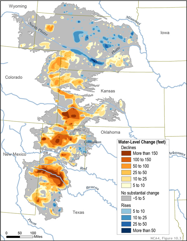
Water levels in the Ogallala (High Plains) Aquifer are monitored through a coordinated network of observation wells operated by state agencies and the U.S. Geological Survey (USGS), with measurements compiled annually into a multi-state dataset. [1][2][3] Each state uses its own well network and measurement protocols, but all contribute data to the USGS High Plains Water-Level Monitoring Study, which produces regular reports on water-level and storage changes. [2][3]
How monitoring works overall
- Observation wells: States maintain networks of dedicated groundwater observation wells screened in the Ogallala/High Plains aquifer. [4][5]
- Measurement frequency: Most wells are measured annually (typically in winter or early spring when pumping is low), though some are measured more frequently or continuously with automated loggers. [2][5][6]
- Data coordination: The USGS assembles water-level measurements from all eight states (Colorado, Kansas, Nebraska, New Mexico, Oklahoma, South Dakota, Texas, Wyoming) and maps changes from predevelopment (~1950) to the present. [2][3]
- Reporting: Results are published in periodic USGS reports and made available through online data portals such as the National Ground-Water Monitoring Network (NGWMN) and state databases. [7][8][1]
State-by-state monitoring approaches
|
State |
Lead agency / program |
Typical methods & notes |
|
Colorado |
Colorado Division of Water Resources / DNR |
Contributes observation-well data to USGS; wells measured periodically and included in High Plains aquifer reports. [9][3] |
|
Kansas |
Kansas Geological Survey (KGS) |
Maintains a large cooperative water-level network; hundreds of wells (including Ogallala) reported to NGWMN with depth-to-water and construction data. [10][8][6] |
|
Nebraska |
Nebraska Department of Natural Resources & USGS Nebraska Water Science Center |
Extensive well network; USGS Nebraska leads the High Plains Water-Level Monitoring Study and compiles multi-state data. [2][3] |
|
New Mexico |
New Mexico Office of the State Engineer (NMOSE) |
Provides Ogallala well data to regional databases; included in USGS multi-state compilations. [3][6] |
|
Oklahoma |
Oklahoma Water Resources Board (OWRB) |
Measures static water levels annually in Ogallala Panhandle wells since the 1960s; some wells have continuous 1‑hour recorders. [9][5] |
|
South Dakota |
SD Department of Environment & Natural Resources (DENR); Rosebud Sioux Tribe |
DENR operates dozens of Ogallala observation wells measured since the late 1970s–early 1980s; the Tribe monitors additional wells, some in real time via satellite links. [4] |
|
Texas |
Texas Water Development Board (TWDB) |
Maintains Ogallala well data; uses automated groundwater loggers at some sites providing hourly data. [9][6] |
|
Wyoming |
State groundwater program (via USGS collaboration) |
Contributes Ogallala/High Plains well measurements to the USGS multi-state dataset. [3] |
Measurement techniques
- Manual measurements: Many observation wells are measured manually with electric tape or steel tape to record depth to water at a standard time of year. [11][5]
- Automated loggers: Some states (e.g., Texas, Oklahoma) install pressure transducers/loggers that record water level continuously (often hourly) and transmit or download data periodically. [5][6]
- Well construction standards: Monitoring wells are typically installed following USGS or state protocols (e.g., PVC casing, screened across the water table) to ensure representative aquifer measurements. [11]
Where the data live
- USGS High Plains Water-Level Monitoring Study: Central hub for multi-state water-level and storage-change maps and reports. [2][3]
- National Ground-Water Monitoring Network (NGWMN): Real-time portal pulling well construction, depth-to-water, and water-quality data from federal, state, and local sources, including many Ogallala wells. [7][8]
- State databases: E.g., KGS (Kansas), TWDB (Texas), OWRB (Oklahoma), SD DENR, etc., each providing downloadable well data and sometimes interactive maps. [10][8][4][6]
If you’d like, I can pull specific well IDs or data portals for a particular state or county you’re working in.
⁂
- https://www.ngwa.org/detail/news/2024/02/21/usgs-publishes-high-plains-aquifer-report
- https://ne.water.usgs.gov/projects/HPA/index.html
- https://ne.water.usgs.gov/ogw/hpwlms/
- http://ogallalawater.org/wp-content/uploads/2018/04/SD_WhitePaper_Summit4.2018.pdf
- https://www.owrb.ok.gov/studies/groundwater/pdf/2023-01-Hydrologic-Investigation-Report-of-the-Ogallala-Aquifer-in-Roger-Mills-County-Oklahoma-2020.pdf
- https://kushal-adhikari.com.np/documents/groundwater-database-for-kansas-new-mexico-oklahoma-and-texas.pdf
- https://www.usgs.gov/apps/ngwmn/index.jsp
- https://www.kgs.ku.edu/Publications/OFR/2023/OFR2023-60.pdf
- https://oklahoma.gov/content/dam/ok/en/owrb/documents/science-and-research/hydrologic-investigations/ogallala-panhandle-water-level-changes-1982-2022.pdf
- https://www.usgs.gov/apps/ngwmn/provider/KSGS/site/392303101095401/
- https://pubs.usgs.gov/fs/2000/0009/report.pdf
- https://pubs.usgs.gov/ds/456/pdf/DS456.pdf
- https://catalog.data.gov/?keyword=Ogallala+aquifer
- https://catalog.data.gov/dataset?tags=ogallala-aquifer
- https://cida.usgs.gov/ngwmn/doc/ProjectReports/Oklahoma_FinalReport_G21AC10478.pdf


No comments:
Post a Comment