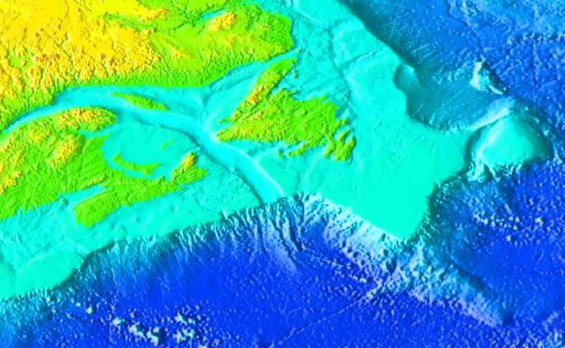
A bathymetric map like this helps show why the gulf’s deep channels and banks matter so much for currents, ice, and fisheries.The Gulf of St. Lawrence is a large inland sea off eastern Canada, shaped by the St. Lawrence River and opened to the Atlantic through the Strait of Belle Isle and Cabot Strait. Its history stretches from Indigenous seasonal use, to European exploration in the 1500s, to its later role as a major shipping, fishing, and ecological corridor.[1][2]
History
Before European contact, Indigenous peoples such as the Mi'kmaq used the gulf seasonally for fishing, and Inuit communities lived along the north shore. Jacques Cartier explored the gulf in 1534, though Basque fishermen likely visited earlier. Over time, the gulf became central to trade and transportation, linking the St. Lawrence River system to the Atlantic and supporting major fisheries.[1][2]
Geography
The gulf is roughly triangular and bordered by Quebec, Newfoundland and Labrador, New Brunswick, Prince Edward Island, and Nova Scotia. It receives large freshwater input from the St. Lawrence River, while Atlantic water flows in through Cabot Strait to balance circulation. Its shape and deep channels make it an important marine passage and a distinctive estuarine environment.[1][3]
Current conditions
Recent live model estimates put the gulf’s central waters around 14°C, with waves near 2.3 m and a surface current around 1.7 km/h NNE. In winter, the gulf often develops extensive sea ice, and Environment Canada’s forecasts show that ice can cover large portions of the region, especially along coasts and in straits. NASA also notes that winter 2024–2025 had unusually low ice compared with typical seasonal patterns.[4][5][6][7]
Why it matters
The gulf is both an ecological hotspot and an economic route, supporting fisheries, whale habitat, and shipping. Ice and storms can make navigation hazardous in colder months, while warmer or low-ice seasons can change marine access and ecosystem conditions.[1][7]
A bathymetric map like this helps show why the gulf’s deep channels and banks matter so much for currents, ice, and fisheries.
⁂
- https://thecanadianencyclopedia.ca/en/article/gulf-of-st-lawrence
- https://www.sciencedirect.com/science/article/abs/pii/S0305748823000622
- https://www.worldatlas.com/gulfs/gulf-of-st-lawrence.html
- https://liveearthviewer.com/ocean/seas/gulf-of-st-lawrence
- https://ice-glaces.ec.gc.ca/cgi-bin/getprod.pl?prodid=FICN17CWIS&wrap=1&lang=en
- https://weather.gc.ca/marine/forecast_e.html?mapID=12&siteID=05807
- https://science.nasa.gov/earth/earth-observatory/low-ice-in-the-gulf-of-st-lawrence-154064/
- https://ice-glaces.ec.gc.ca/cgi-bin/getprod.pl?prodid=FICN17CWIS&wrap=1&lang=en&q=1
- https://niche-canada.org/2023/06/08/ecologies-knowledge-and-power-in-the-gulf-of-st-lawrence-region-c-1500-present/
- https://cdnsciencepub.com/doi/10.1139/e99-030
- http://parkscanadahistory.com/geology/paper-53.pdf
- https://e-navigation.canada.ca/topics/ice/central/charts?carte=WIS28C
- https://icelogistics.info/ice-charts?iceChartProductId=2216
- https://iceweb1.cis.ec.gc.ca/IceGraphJ/page1.xhtml?lang=en
- https://www.eldoradoweather.com/canada/CanadaAlerts/marine/Ice Charts/gulf-of-st-lawrence.php
- https://weather.gc.ca/marine/marine_bulletins_e.html?Bulletin=ficn17.cwis
- https://www.buoyweather.com/forecast/marine-weather/spot/St+Lawrence/@-21.85,150.025
- https://en.wikipedia.org/wiki/Gulf_of_St._Lawrence
- https://publications.gc.ca/collections/collection_2025/eccc/en40/En40-386-7-1991-eng.pdf


No comments:
Post a Comment